| Click here for Home Page to see List of All My Trips and Three Methods to search my Travelogue website for web pages of interest to you |
| Devil's Slide Trail with Thousands of Nesting Seabirds and Beautiful Pillar Point Harbor in California |
****************************************
In case if you see overlapped lines of text or some lines of text become obscured behind a picture on this web
page, please change the page magnification (zoom) factor to eliminate such problems by pressing these two
keys "Ctrl +" simultaneously or these two keys "Ctrl -" simultaneously. Depending on your PC setting, it may
be necessary to reduce the magnification factor several steps down in order to eliminate the overlap and
obstructed text lines.
Please press the F11 key (Fn key and F11 key on laptop PC) on your keyboard to get full-screen view of
photos and web page. Pressing F11 key again will return to your normal screen with various tool bars.
****************************************
| 讀萬卷書 行萬里路 |

寬廣的觀海休閒步道。
A view of Devil's Slide Trail that I took on the afternoon of October 25, 2017. It is an "abandoned" paved old
coastal Highway 1 between the cities of Pacifica and Montara on California coast. It is about 18 miles south
of San Francisco and 6 miles north of Half Moon Bay. The trail is paved, with separate lanes for hikers and
directional bike traffic. The total cost to convert the abandoned highway to the scenic hiking trail is about $2
million with breathtaking views of the Pacific Ocean from its rocky cliffs.
路邊高叢的懸崖峭壁, 觸目惊心。
The steep, precarious cliff on the east side of Devil's Slide Trail. The name Devil's Slide comes from the
rockfalls and landslides that frequently occurred here during winter storms and closed the old Highway 1
frequently for several months for each occurrence here before the new Tom Lantos Tunnels were constructed
to bypass this problem.
Now the "abandoned" old 1.3-mile section of Highway 1 here becomes a wonderful paved wide hiking trail for
pedestrians and bicyclists to enjoy the spectacular views of the oceans, cliffs, waves, seabirds and whales.
Four more impressive views of Devil's Slide can be seen here, here, here and here
.jpg)


山水之間,海天一色,氣勢磅礴,神清氣爽, 一望無際的汪洋大海,神奇壯美,令人嘆
為觀止。
Fantastic views from the parking lot at the south end of the 1.3-mile Devil's Slide Trail. The Devil's
Slide Bunker is visible on the top on left side.
為觀止。
Fantastic views from the parking lot at the south end of the 1.3-mile Devil's Slide Trail. The Devil's
Slide Bunker is visible on the top on left side.


Two of the three scenic Overlooks, with telescope, benches, Interpretative Panels and trash can, along this
1.3-mile Devil's Slide Trail for tourists to enjoy the fantastic views. A lot of information on Devil's Slide are
available on the 30-minute video here and on this website.
1.3-mile Devil's Slide Trail for tourists to enjoy the fantastic views. A lot of information on Devil's Slide are
available on the 30-minute video here and on this website.


居高臨下俯視粗獷礁石。
The Devil's Slide Rock near Devil's Slide Trail on October 25, 2017.
The Devil's Slide Rock near Devil's Slide Trail on October 25, 2017.

I used my compact super-zoom camera (Canon PowerShot SX 60 HS) with 65X optical zoom to zoom in and
I saw quite a few cormorants on this bird rock (Devil's Slide Rock) on October 25, 2017, the date of my first
visit of Devil's Slide Trail.
I saw quite a few cormorants on this bird rock (Devil's Slide Rock) on October 25, 2017, the date of my first
visit of Devil's Slide Trail.

Zoom in some more for better view of cormorants on this bird rock.

The San Pedro Rock, about 1.5 miles north from the Devil's Slide Rock as viewed from Devil's Slide Trail.
觀海休閒步道,觀景台,供遊客欣賞海景的座椅,開闊的視野, 邊聊天邊看海景, 與你的
情人娓娓道來, 最富詩情畫意。
Interpretive signs are placed at key points along the trail and describe the history, geography and the marine
and avian communities that live and migrate through here. At these provided overlooks, visitors may rest on
benches or gaze through observation scopes and take in the views of the vast Pacific Ocean or the migration
whales or thousands of busy nesting seabirds on the bird rock or Farallon islands 30 miles away.

澎湃洶湧的浪花,飛濺的浪花, 吸引過路的遊客觀浪。
The powerful waves below the steep cliff on the windy day of October 25, 2017.
The powerful waves below the steep cliff on the windy day of October 25, 2017.

岩石島。
Zoom in for a closer view of the magnificent San Pedro Rock.
Zoom in for a closer view of the magnificent San Pedro Rock.

By zooming in some more, I also saw some cormorants on San Pedro Rock on October 25, 2017.

Three pelicans flying through this area.

The south entrance of Tom Lantos Tunnels for the new Highway 1 that goes through the mountain to the east
of the steep cliff of Devil's Slide.
Map: Click here for interactive Google Map showing locations of Devil's Slide Trail (South Parking Lot) and of
south entrance of Tom Lantos Tunnels for Highway 1
of the steep cliff of Devil's Slide.
Map: Click here for interactive Google Map showing locations of Devil's Slide Trail (South Parking Lot) and of
south entrance of Tom Lantos Tunnels for Highway 1

The parking lot at the south end of Devil's Slide Trail.
Direction to South Parking Lot of Devil's Trail:
To reach this South Parking Lot, I set the destination of my GPS Navigator at the junction of CA-1 (I.e.,
Highway 1) & Bunker Point, Montara, CA. Then drive north on CA-1 for about 500 feet to reach the junction of
Highway 1 and South End of Devil's Slide Trail. There is a traffic light at this junction near the entrance to Tom
Lantos Tunnels . At this traffic light, turn left (west) onto Devil's Slide Trail and go north about 500 feet to reach
the South Parking Lot.
Map: Click here for interactive Google Map showing local map near south end of Devil's Slide Trail and South
Parking Lot
There is another parking lot at the north end of Devil's Slide Trail.

High atop the coastal peak at Devil's Slide is crumbling remains of Devil's Slide Bunker that looks as though it
is about to tip off the edge of the summit and slide into the sea. This bunker was originally built during World
War II as a triangulation and observing station and was once simply a part of a much bigger set of coastal
buildings and facilities to protect San Francisco. When in service (before Radar technology), a watcher
equipped with a set of binoculars and compass would keep watch out at sea and if they spotted any enemy
ships they simply radioed a massive six-inch gun not far away which would sink the enemy ships before they
got close.
However, with the advent of more modern missile defenses and Radar technologies, this watch station bunker
became obsolete and the entire site was abandoned in 1949, leaving an empty bunker atop Devil’s Slide.
Today the Devil’s Slide Bunker sits on private property and is not open to the public.

The parking lot with toilet facilities and drinking water fountain.

一片晴朗而遼闊的蔚藍天空, 藍綠色壯闊的大海,湛藍浩瀚無邊的太平洋,水和天連在
一起,寬廣豪放之美,憑欄遠望,令人心曠神怡。
Breathtaking view of the Pacific Ocean on the sunny day of October 25, 2017 with blue sky and deep blue
ocean. Absolutely gorgeous!
一起,寬廣豪放之美,憑欄遠望,令人心曠神怡。
Breathtaking view of the Pacific Ocean on the sunny day of October 25, 2017 with blue sky and deep blue
ocean. Absolutely gorgeous!

掛壁公路的奇、險、雄、峻表現的淋漓盡致。
Hiking from south to north, Devil's Slide Trail keeps on going uphill.
Hiking from south to north, Devil's Slide Trail keeps on going uphill.


Dogs on leash are allowed on Devil's Slide Trail.

Zoom in for a closer view of the bunker and we saw some graffiti on the bunker.

One of several Interpretive Panels on Devil's Slide Trail. A good introduction and detailed video description of
Devil's Slide Trail is available on this website.
There are about 20,000 gray whales migrating between their winter calving lagoons in Mexico and summer
feeding grounds in the Arctic. In the Spring north-bound migration season, many mother gray whales with
their babies swim closer to the shore and are easier to see from shore. Being high on the cliff, Devil's Slide
Trail provides excellent Top-Down view for visitors to enjoy watching these migrating whales. So, I will come
here again in the spring season to watch migrating whales in action.


Magnificent views of the dramatic Pacific coastline at Montara State Beach just south of Gray Whale Cove
State Beach.
After touring Devil's Slide Trail, we drove south on Highway 1 for a short distance and saw some surfers and
people at the gorgeous Montara State Beach.
State Beach.
After touring Devil's Slide Trail, we drove south on Highway 1 for a short distance and saw some surfers and
people at the gorgeous Montara State Beach.

海浪湧向沙灘, 衝浪 和 賞鯨 的好地方。
Some surfers surfing at Montara State Beach. A fantastic panoramic aerial view of this area and Gray Whale
Cove State Beach can be seen here. Mother and baby gray whales can often be spotted close to the shore
of this scenic beach (Montara State Beach and Gray Whale Cove State Beach) during whale migration season
in March, April and May as shown here, here,here and here. Sometimes dolphine can also be seen here.

Then we arrived at the busy fishing village known as Pillar Point Harbor on October 25, 2017. It is near
Princeton-by-the-Sea located at 1 Johnson Pier, Half Moon Bay, CA 94019. It is off Highway 1 at the northern
end of Half Moon Bay and about 6 miles south of Devil's Slide Trail. The local communities are Princeton by the
Sea and El Granada as described here.
Map: Click here for interactive Google Map showing location of Pillar Point Harbor

Many fishing boats and pleasure boats in Pillar Point Harbor. People can buy fresh fish or fresh live Dungeness
crabs from some of these fishing boats as described on this website. If you are looking for high quality
seafood, this is the place you should come. If you want wild caught rock cod, this is the place you should come.
This is something you can't compare with the farm raised cod. They also have shrimp, salmon and abalone for
sale too. And you should come early, after lunch time, some of these fishing boats are gone.
Detailed local map of Pillar Point Harbor is available here. Aerial view of Pillar Point Harbor can be seen here
and here.
crabs from some of these fishing boats as described on this website. If you are looking for high quality
seafood, this is the place you should come. If you want wild caught rock cod, this is the place you should come.
This is something you can't compare with the farm raised cod. They also have shrimp, salmon and abalone for
sale too. And you should come early, after lunch time, some of these fishing boats are gone.
Detailed local map of Pillar Point Harbor is available here. Aerial view of Pillar Point Harbor can be seen here
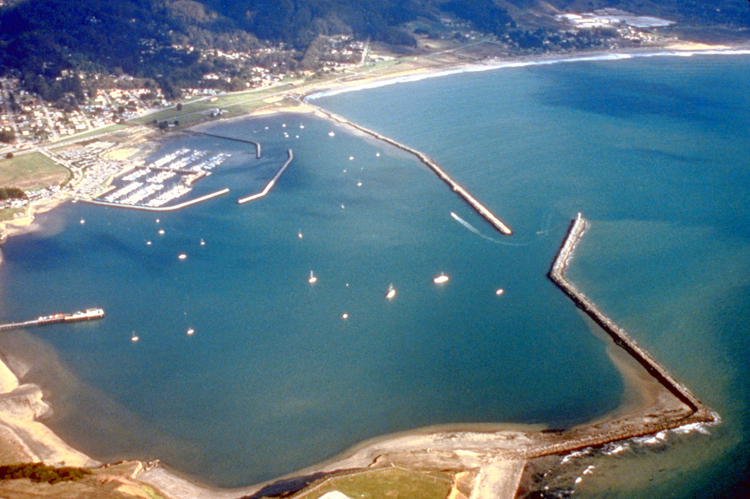
and here.


Piles and Piles of crab traps for crabbing boats at Pillar Point Harbor.

There are many seafood restaurants and shops at Pillar Point Harbor. In the crab season (November 15-
June 2014), customers can enjoy crab cioppino, crab linguini, crab cocktail, crab Louie, crab sandwiches, crab
cakes, a half crab entrée and a whole crab entree served with warm butter.
June 2014), customers can enjoy crab cioppino, crab linguini, crab cocktail, crab Louie, crab sandwiches, crab
cakes, a half crab entrée and a whole crab entree served with warm butter.

As a bird watcher, I was happily surprised to see such high concentration of huge number of big pelicans and
other birds at Pillar Point Harbor on October 25, 2017. I was standing on Pillar Point Harbor Blvd in watching
and taking pictures of these pelicans in action.
other birds at Pillar Point Harbor on October 25, 2017. I was standing on Pillar Point Harbor Blvd in watching
and taking pictures of these pelicans in action.

There are also huge number of pelicans and other birds perching on the long rock jetty (breakwater) of Pillar
Point Harbor on October 25, 2017.
During late summer and fall, schools of fish often concentrate in the harbor and provide feeding grounds for
large numbers of Brown Pelican, Elegant Terns and Heermann's Gull.
I took a movie of the spectacular views when huge number of pelicans took off from the water
simultaneously as shown on the following YouTube website:
https://youtu.be/gjX-BgP699Q
I also took a movie scan of huge number of pelicans and other birds perching on the long rock jetty on
October 25, 2017 as shown on the following YouTube website:
https://youtu.be/t606MEl2j9E
I also took a movie of many pelicans in action poking their heads and big bills into water to catch fish in Pillar
Point Harbor as shown in the following YouTube website. Such action is an indication of lots of fish in Pillar
Point Harbor. It is such big school of fish that attracts the high concentration of so many pelicans and other
birds to Pillar Point Harbor to feed.
https://youtu.be/FVpV-GIu_G0


In addition to many pelicans, we also saw other kinds of birds at Pillar Point Harbor.
I took a movie of one of many shorebirds busily poking its beak up-and-down quickly into the wet sand to
feed along the shore of Pillar Point Harbor as shown in the following YouTube movie:
https://youtu.be/GolkTAKIq-Q
I took a movie of one of many shorebirds busily poking its beak up-and-down quickly into the wet sand to
feed along the shore of Pillar Point Harbor as shown in the following YouTube movie:
https://youtu.be/GolkTAKIq-Q


Some pelicans are in the air.

The picturesque Romeo Pier as viewed from the hiking trail between Tide Pool Parking Lot and Maverick's
Beach. The old, shaky yet scenic Romeo Pier at Pillar Point Harbor is an icon of the harbor landscape. The
pier is a popular image for photographers and landscape painters visiting this harbor. Built in 1940, the
Romeo Pier served as a place for Coastside fishermen to unload sardines and salmon for decades, long
before the harbor rock jetty/breakwater was built.
From this hiking trail near Tide Pool Parking Lot, we also heard loud barking of sea lions on or near Romeo
Pier.
We also heard foghorn in Pillar Point Harbor and I love to hear the sound of foghorn. It brings back sweet
memory about 40 years ago when I heard foghorn while I was in Mendocino in northern California coastal
area for one night. I was a foreign student in University of California at Berkeley. The Foreign Student Center
arranged a 3-day tour for a group of foreign students, including me, to northern California coastal area. The
northern California coastal areas are often very foggy such that foghorn at the coastal lighthouse comes on
frequently.

The boats and the inner rock jetty (breakwater) as viewed from the hiking trail near the Tide Pool Parking Lot.

We saw a loon in the harbor.
I took a movie clip of the loon swimming with the background sounds of barking sea lion and of foghorn as
shown on the following YouTube website:
https://youtu.be/BrWzcBFFofI
I took a movie clip of the loon swimming with the background sounds of barking sea lion and of foghorn as
shown on the following YouTube website:
https://youtu.be/BrWzcBFFofI

The head of a sea lion popped out of water, some sea lions are swimming or frolicking in the harbor.
In view of so many fishing boats bringing back all kinds of fresh fish, of piles and piles of crab traps at this
harbor and of the high concentration of hundreds of big fishing birds, pelicans, at this harbor, the seafood in
these seafood restaurants at this harbor must be very delicious.
Pillar Point Harbor is home port to a vital commercial fishing industry, to sport fishermen, and to pleasure
boaters seeking the amenities this modern coastal harbor facility provides. It is a major commercial and sport
fishing harbor, and is host to many public events including the annual Mavericks surfing competition.
The entrance leads to a spacious parking lot where there's a Farmers Market every Sunday. Some visitors are
enjoying the magnificent views of the dramatic Pacific coastline and sunset view, some are hiking in this area,
some are fishing or crabbing on the pier or on the rock jetty or on the rental kayak, some are enjoying excellent
seafood in the restaurants, some are kayaking or stand-up board paddling on the calm water in the harbor.
There are even two spaces for you to clean your catch before you head back home.
There is a small surf/rental shop, bait shop and restaurants serving some of the best seafood and clam chowder
around.
Pillar Point Harbor is a fun place with many kinds of interesting activities for visitors to enjoy.
The tripadvisor's reviews of restaurants near Pillar Point Harbor is at:
https://www.tripadvisor.com/RestaurantsNear-g32469-d7001478-Pillar_Point_Harbor-Half_Moon_Bay_California.html
The yelp's reviews of seafood restaurants near Pillar Point harbor is at:
https://www.yelp.com/search?cflt=seafood&find_loc=Pillar+Point+Harbor+Blvd%2C+Half+Moon+Bay%2C+CA+9
4019

The Pillar Point Air Force Radar Tracking Station on the top of Pillar Point Bluff above the harbor.
Pillar Point Bluff offers hikers, joggers, bicyclists, and dog-walkers a chance to take in the stunning views of
the ocean in front and the harbor behind, and sounds of the Pacific Ocean. The 220-acre bluff top includes a
section of the California Coastal Trail and offers views of Half Moon Bay Harbor, agricultural lands and the
world famous Mavericks surf break. The aerial view from a drone of Pillar Point Bluff can be seen here.
The Legendary Waves Known as Maverick
The famous Maverick surf break is located approximately half a mile off shore due west from the Pillar Point
Air Force Tracking station and is best viewed with binoculars. Aerial views from a drone of Surfing Maverick
Waves can be seen here, here, and here. On very rare occasions, conditions produce famous Maverick
Waves that are larger than anywhere else on earth, fearsome waves up to 60 feet tall. When it does, this
town becomes the center of the world for big wave surfers. Brave surfers surfing the most terrifying Giant
Maverick Waves can be seen here, here, here and here.
In Spring season, flowers everywhere on the Pillar Point Bluff!! There are yellow flowers blooming all along
the trails on the bluff and cliffs. It was quite a view with the ocean in the back drop. There is a separate
parking lot located at Airport St, Moss Beach, CA 94038 which is the Trailhead for visitors to hike up to the
220-acre bluff.
Map: Click here for interactive Google Map showing location of Pillar Point Bluff Parking Lot and Hiking Trails
on the 220-Acre bluff
The bluff above the beach can be a good vantage point for observing sea birds. Sooty Shearwater may be
seen by the thousands in summer and early fall, often quite close to shore.
The Tide Pool Parking Lot at the beach level below the bluff is at the end of West Point Avenue and near the
gate that keeps you from getting too close to the Pillar Point Air Force Station. The Tide Pool Parking Lot
is the Trailhead for a 25-minute hiking trail along northern border of the harbor to Mavericks point. Low tide
rocky seascape at Pillar Point can be seen here.
Map: Click here for interactive Google Map showing locations of Pillar Point Air Force Station and Tide Pool
Parking Lot.
蜿蜒曲折, 豪邁的觀海休閒步道。
藍天碧海,浪漫美麗的海岸線,氣勢宏偉,一幅絕美景觀。

Beautiful inside view of Tom Lantos Tunnels when we went through this tunnel from north to south on May
16, 2018.
16, 2018.

I came to visit Devil's Slide Trail again on May 16, 2018, seven months after my first visit. This time, I saw
many tiny black dots on the top of the bird Rock (Devil's Slide Rock). May 16 is in the middle of breeding
season of seabirds (Common Murres) from April to July.
many tiny black dots on the top of the bird Rock (Devil's Slide Rock). May 16 is in the middle of breeding
season of seabirds (Common Murres) from April to July.
Zoom in a little bit and I saw many tiny black dots on the tops of both the higher bird rock and the lower wet
bird rock on the left side.
bird rock on the left side.


Zoom in some more on many tiny black dots on the top of Devil's Slide Rock.

Zoom in even more on many black dots on the top of Devil's Slide Rock.

Zoom in some more. We now can see that those tiny black dots are huge number of seabirds on the top of
Devil's Slide Rock. Most of them are black color on the back side and white color on the belly side which is
an indication of the seabird Common Murres.
These seabirds spend most of the time on ocean-water far away from lands. It is only during the breeding
season, from April to July, millions and millions of seabirds from wide open ocean gather in crowded colonies
on the very limited surfaces of isolated bird islands or isolated bird rocks to nest, to mate, to lay eggs and to
raise their baby birds. They choose these isolated bird islands or isolated bird rocks surrounded by deep
water so that these nesting seabirds, their eggs and their baby birds are safe from land based predators,
such as coyote, fox, wolf, bear, etc.
There are also a few Cormorants on the top of this bird rock. Cormorants are black colored on the entire
body including both back side and belly side.

In this picture, notice the two Cormorants on the right lower corner are sitting on their nests on the rock.
But all other Common Murres in this picture are just standing on the rock surface. Common Murres do not
build any nest, and just lay their eggs on the bare rock surface. Their eggs have a special "design" with one
end large and the other end small. With such special "design", if their eggs are disturbed on the rock surface,
those eggs just roll in very tight circle and are unlikely to roll far away and fall down the cliff.


I also zoomed in on the lower bird rock and saw many Cormorants on the top of this lower bird rock on May
16, 2018.
16, 2018.

The San Pedro Rock as viewed from Highway 1 in Pacifica on May 16, 2018.

The San Pedro Rock as viewed from Highway 1 near Pacifica State beach on May 16, 2018.

From Devil's Slide Trail, zoom in on Farallon Islands about 30 miles away on May 16, 2018. Some people take
tour boat or fishing party boat from San Francisco or Berkeley to go near the area of Farallon Islands for bird
watching or fishing.
tour boat or fishing party boat from San Francisco or Berkeley to go near the area of Farallon Islands for bird
watching or fishing.

Being still in Spring season, we saw many beautiful wildflowers on the steep slopes or cliff along Devil's Slide
Trail on my second visit on May 16, 2018.
Trail on my second visit on May 16, 2018.


Beautiful California poppies along Devil's Slide Trail seen on May 16, 2018.

More California poppies and purple wildflowers on the cliff along Devil's Slide Trail.

Many California poppies and purple wildflowers on the cliff along Devil's Slide Trail.

More spring wildflowers on the cliff along Devil's Slide Trail.


On our second visit of Pillar Point Harbor on May 16, 2018, we did not see those huge number of pelicans
probably because there was no big school of fish in the harbor. Instead, we saw lots of beautiful California
poppies along Capitstrano Road.
probably because there was no big school of fish in the harbor. Instead, we saw lots of beautiful California
poppies along Capitstrano Road.


There are also other kinds of beautiful flowers in Pillar Point harbor.


In addition to Cormorants, there were also quite a few smaller Common Murres on this lower bird rock.

Spectacular view of the Pacific coast as viewed from a hill top of Milagra Ridge. The small Milagra Ridge
Parking and Trailhead is located about 1,000 feet west of the junction of Sharp Park Rd & College Rd.,
Pacifica, Ca. 94044. It is about 7 miles south of San Francisco. This is part of Golden Gate National
Recreation Area.
Historically, the U.S. Army installed a gun battery with two 6-inch guns here in the 1940’s, and during the
Cold War built a Nike missile station on Milagra Ridge and nearby Sweeney Ridge to protect San Francisco
Bay area.
I took a movie scan of the fantastic panoramic view from Milagra Ridge as shown in the following YouTube
website:
https://www.youtube.com/watch?v=SPyo5rnOmj8&feature=youtu.be
We thank our special good friend for treating us a fantastic lunch in a wonderful restaurant, Koi Palace, in
Daly City on May 16, 2018. This restaurant is like a Palace serving delicious foods with excellent services. I
enjoyed this lunch very much. After the lunch, we drove for a short distance to the small Milagra Ridge
Parking near the Trailhead. We parked our car at Milagra Ridge Parking and took a short hike up to one of
the hill tops to enjoy the breathtaking views.

Zoom in on the Pacifica Municipal Pier. Many people are fishing from this pier. Some other people come to
this pier during whale migration season to watch migrating whales from this pier.
this pier during whale migration season to watch migrating whales from this pier.

Zoom in on San Pedro Rock and Point San Pedro on the southern part of Pacifica.
After enjoying the fantastic views from Milagra Ridge in Pacifica, we drove south on Highway 1 through Tom
Lantos Tunnels for our second visit of Devil's Slide Trail and second visit of Pillar Point Harbor in the
afternoon of May 16, 2018 as described above on this website.
After enjoying the fantastic views from Milagra Ridge in Pacifica, we drove south on Highway 1 through Tom
Lantos Tunnels for our second visit of Devil's Slide Trail and second visit of Pillar Point Harbor in the
afternoon of May 16, 2018 as described above on this website.

Many boats at Pillar Point Harbor.

A boat and flowers greets visitors at the entrance to this unique fishing village.
There are fishing boats docked along the Johnson Pier advertising their offerings. Some visitors are buying
fresh fish or crabs from some fishing boats docked at the harbor. This picture shows many live Dungeness
crabs for sale on a fishing boat.
fresh fish or crabs from some fishing boats docked at the harbor. This picture shows many live Dungeness
crabs for sale on a fishing boat.

But if cooking doesn’t sound appealing to you, you can leave the work to the fine folks at Princeton Seafood
Company who are happy to clean and cook your fresh catch. You walk a few feet from fishing boat on main
dock walkway up to this nearby Princeton Seafood Company and have your fresh fish or your live crabs
cleaned and cooked for you. It is located at 9 Johnson Pier, Half Moon Bay, CA 94019, (650) 726-2722, www.
princetonseafood.com.


This Princeton Seafood Co - Restaurant & Market also sell many live crabs, fish and cooked crabs.

The Princeton Seafood Company Restaurant also has a window for visitors to buy take-out seafood to eat
them on several outdoor picnic tables nearby or in their own cars. We ordered a take out crab cake sandwich
and enjoyed it very much.
We came again on February 14, 2020 planning to enjoy nice seafood lunch in the famous Sam’s Chowder
House (located at 4210 North Cabrillo Highway, (650) 712-0245, www.samschowderhouse.com). But it was
Valentine's Day with huge number of customers such that the parking lot was full and there were two long lines
of cars parked on both side of Cabrillo Highway (i.e., Highway 1) for miles. So, we gave up on this famous
restaurant on the busy day, and settled on this take out window.

A large field of yellow flowers along Highway 1 a couple miles south of Pillar Point Harbor.
Half Moon Bay has one of the largest concentrations of Dungeness crab with more than 50 commercial boats
fishing off Pillar Point Harbor.
Please see how people use crab traps to catch many Dungeness crabs on Half Moon Bay on these YouTune
websites:
https://www.youtube.com/watch?v=DMB5jljn6Fg
https://www.youtube.com/watch?v=I_EYwXHdtyM
Please also see people use fishing rod to catch pink colored rock fish on Half Moon Bay plus crabbing on this
YouTube website:
https://www.youtube.com/watch?v=_mdK77XhPTI
The Hanging Gardens of Devil's Slide.

We visited Devil's Slide again on June 26, 2020 and saw some visitors hiking to visit Devil's Slide Bunker.
There is a small roadside parking lot only about 0.2 miles north of the Bunker. People can park their cars on
this small parking lot and take a short walk to visit this Bunker.
Similarity to Walkway Over the Hudson at Poughkeepsie, New York:
The history of the tourists' attraction of Devil's Slide Trail originating from restored 1.3-mile section of
abandoned coastal Highway 1 in California is somewhat similar to the history of the tourists' attraction of
Walkway Over the Hudson at Poughkeepsie in the State of New York originating from restored 1.28-mile of
abandoned, fire-damaged Railroad Bridge as described near the end of my web page at:
http://www.shltrip.com/Autumn_in_Eastern_NY_1.html
I enjoyed very much visiting these two tourists' attractions.

Gray Whale Cove State Beach just south of Devil's Slide Bunker as viewed from Highway 1. It features a
sheltered cove surrounded by abrupt cliffs. The beach is named for the frequent sightings of gray whales from
the beach during the whale migration season. 360-degree view of Gray Whale Cove and Beach can be seen
here. In spring, wildflowers brighten the bluffs above the beach.
sheltered cove surrounded by abrupt cliffs. The beach is named for the frequent sightings of gray whales from
the beach during the whale migration season. 360-degree view of Gray Whale Cove and Beach can be seen
here. In spring, wildflowers brighten the bluffs above the beach.

Several outdoor picnic tables near the seafood take-out window and the Princeton Seafood
Restaurant/Company. There is a large public parking lot behind this building.
Restaurant/Company. There is a large public parking lot behind this building.

This white-board at the beginning of the dock (Johnson Pier) lists fishing boats with live crabs and fresh fish for
sale for the day.
sale for the day.