Click here for Home Page to see List of All My Trips and
Three Methods to search my Travelogue website for
web pages of interest to you
Three Methods to search my Travelogue website for
web pages of interest to you
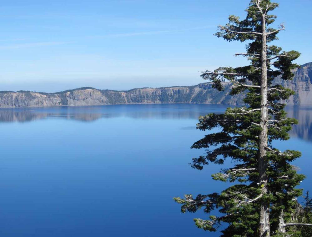
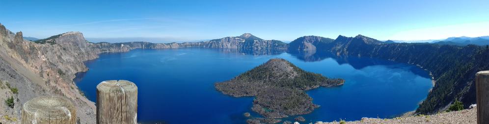
| Tour of Crater Lake National Park in Oregon |

北美最深最藍的火山湖,藍天白雲,地處高山之巔,清澈晶瑩的浩瀚天池,醉人的湖
藍,雪山融水形成的湖泊,完全與外界隔絕,渾然天成,風格獨特,氣象萬千。
Fantastic views when we were driving on the Rim Drive around the crystal clear, beautiful, deep blue Crater
Lake in Oregon. It is the deepest lake (1,949 feet) in the USA at an elevation of 6,176 feet above sea level.
The lake diameter is about 6 miles (10 Km). Crater Lake National Park is in southern Oregon, USA.
We toured Crater Lake National Park twice: The first time was 15 years ago in August 2004. It is wonderful
to come back and visit again in September 2019. My compact super-zoom camera in 2019 is much better
than my old camera 15 years ago. I have also gained 15 years of additional experience in photography
hopefully to take better pictures of stunning beautiful Crater Lake.
Map: Click here for interactive Google Map showing the location of Crater Lake National Park


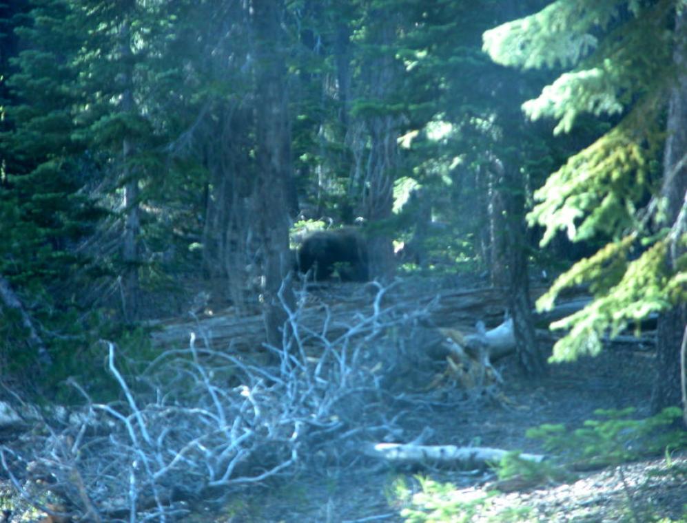
We saw a bear in the woods near a campground in Crater Lake National Park.

We saw a deer near the Rim Drive around the Crater Lake

A lovely waterfall cascades down the steep slope located along the East Rim Drive within the Crater Lake
National Park。 I am not sure if this is Plaikni Falls or Vidae Falls.
Map: Click here to see interactive Google Map showing locations of Plaikni Falls and Vidae Falls.
National Park。 I am not sure if this is Plaikni Falls or Vidae Falls.
Map: Click here to see interactive Google Map showing locations of Plaikni Falls and Vidae Falls.

湖天一色,夢幻般的湖藍,世外桃源般的寧靜和純淨,這麽深,這麽純淨,這麽藍的湖
泊。
About 7,700 years ago, the Stratovolcano, Mount Mazama, with peak estimated at 12,000 feet high collapsed
down following a large eruption and created this caldera of Crater Lake.
泊。
About 7,700 years ago, the Stratovolcano, Mount Mazama, with peak estimated at 12,000 feet high collapsed
down following a large eruption and created this caldera of Crater Lake.

Caldera - Collapses of Mount
Mazama Stratovolcano to form
Caldera of Crater Lake about 7,700
years ago.
The largest and most explosive type
of volcanic eruptions that eject tens
to hundreds of cubic kilometers of
magma onto the Earth's surface.
When such a large volume of magma
is removed from beneath a volcano,
the volcanic mountain and the ground
collapse down into the emptied
space underneath, to form a huge
depression called a caldera. Some
calderas are more than 25
kilometers in diameter and several
kilometers deep. Some calderas are
filled with lakes like this Crater Lake.
More information on Crater Lake is available at the following websites:
http://www.nps.gov/crla/index.htm
http://www.nps.gov/archive/crla/home.htm
http://www.nps.gov/crla/index.htm
http://www.nps.gov/archive/crla/home.htm
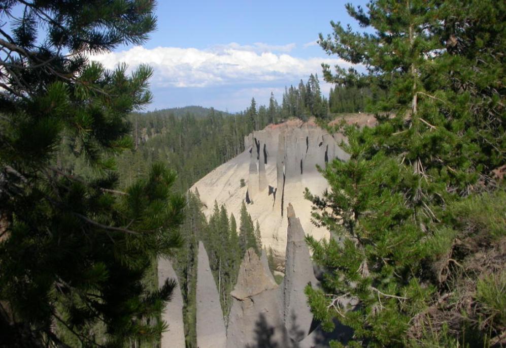
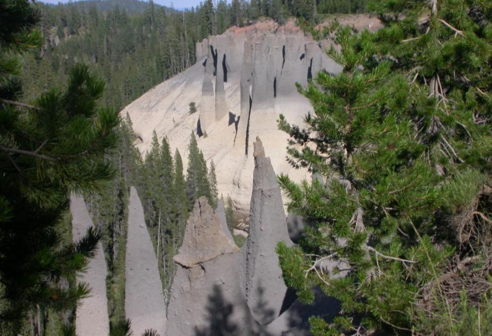
能夠看到這樣奇特的火山地形可說是非常值得。這些色彩繽紛的火山尖塔從峽谷壁上刺
出來,每一根都有約 100 feet (30m) 長。這些尖尖的塔是由火山冒出來的氣體,夾雜著火
山灰凝固而形成的,這樣一整片非常奇特壯觀。來到這個景點要沿著 Pinnacle Road 開
6 mi (10km)。
Pinnacles Overlook and The Pinnacles Trail: Pinnacles along a creek near Crater Lake。
Map: Click here for interactive Google Map showing location of Pinnacles Overlook
出來,每一根都有約 100 feet (30m) 長。這些尖尖的塔是由火山冒出來的氣體,夾雜著火
山灰凝固而形成的,這樣一整片非常奇特壯觀。來到這個景點要沿著 Pinnacle Road 開
6 mi (10km)。
Pinnacles Overlook and The Pinnacles Trail: Pinnacles along a creek near Crater Lake。
Map: Click here for interactive Google Map showing location of Pinnacles Overlook

Volcanic Pumice Desert near Crater Lake, Oregon. These volcanic pumice rocks have many tiny air bubbles
and holes such that they look almost like sponge. These volcanic pumice rocks can float on the water because
of all those tiny air bubbles. Practically nothing can grow on this volcanic pumice desert.
and holes such that they look almost like sponge. These volcanic pumice rocks can float on the water because
of all those tiny air bubbles. Practically nothing can grow on this volcanic pumice desert.


看著入夜後滿天星斗,回歸自然樸實,也是一種嚮往的美好。
Crater Lake is listed as one of top 10 dark sky locations at night by the National Park's Dark Sky Team.
Expansive views are available in all directions from the rim of the Crater Lake for night sky photography. It is
spectacular in daylight but is also astonishing at night.
Milky Way over night sky of Crater Lake:
Some people stay at night at Crater Lake to enjoy spectacular views of Milky Way Galaxy, a glittering jewel
box of light, over the night sky of Crater Lake. Many of such fantastic photos can be seen here. These
photographers captured the rising Milky Way and the crescent Moon in the crystal clear night sky of the
Crater Lake in Oregon. There was no escape from such breathtaking intoxication!
Enchanting Aurora Display (Northern Light) Dancing over night sky of Crater Lake:
Normally, the aurora is visible at night only in the northern territories such as Canada, Alaska, Iceland, etc.
But on special nights of powerful solar magnetic storms reaching the earth, some special devoted
photographers came at night to Crater Lake to capture the most magnificent celestial spectacles of aurora
(northern light) dancing over the night sky of Crater Lake as shown by video and photos at the following
websites:
https://traveloregon.com/things-to-do/destinations/lakes-reservoirs/aurora-over-crater-lake/
https://www.youtube.com/watch?v=EmnL-ZalSM4
https://goldpaintphotography.com/2012/06/17/aurora-over-crater-lake/
https://slate.com/technology/2013/06/crater-lake-aurora-surprise-pink-northern-lights-over-oregon.html
When we were touring the Crater Lake, we were at elevation above 7,000 feet. The lake water surface is at
about 6,176 feet of elevation above sea level. The Rim Drive with various Vista Points around the lake are
about 1,000 to 2,000 feet above the lake water surface.
When we came down to the ground level at the motel, our caped empty water bottles were squashed as shown
in the picture above due to the difference in air pressures above 7,000 feet elevation and at ground level.
Map: Click here to see Google Map showing location of Crater Lake in southern Oregon
Map: Detailed park map is available at the following websites:
http://www.crater.lake.national-park.com/map.htm
http://www.willhiteweb.com/crater_lake_national_park/sights_093.htm
http://www.nps.gov/archive/crla/crlamap.htm
In case if you see overlapped lines of text or some lines of text become obscured behind a picture on this web
page, please change the page magnification (zoom) factor to eliminate such problems by pressing these two
keys "Ctrl +" simultaneously or these two keys "Ctrl -" simultaneously.
Please press the F11 key on your keyboard to get full-screen view of photos and web page. Pressing F11 key
again will return to your normal screen with various tool bars.
| 讀萬卷書 行萬里路 |

湖光山影,四周有懸崖萬丈,壁立千仞的崇山峻嶺環抱,碧波蕩漾,碧藍和青翠,蒼穹
碧野,山中有湖,湖中有島,島上有山的連環風景帶。
Stunning beautiful lake! Views all around the Rim Drive are incredible. The overlooks are all in good condition
and parking is easy.
碧野,山中有湖,湖中有島,島上有山的連環風景帶。
Stunning beautiful lake! Views all around the Rim Drive are incredible. The overlooks are all in good condition
and parking is easy.
幽深秀麗的湖畔景色,山光水色,相映如畫, 靜觀湖景,凝思遐想。
明凈如鏡的湖水,雄渾壯美的大湖風光,如此純淨的深藍色,有著寬廣豪放之美,感天
動地的一片藍,蓝色狂想曲。
Crater Lake is one of the most amazingly beautiful places on earth!
動地的一片藍,蓝色狂想曲。
Crater Lake is one of the most amazingly beautiful places on earth!
俯瞰湖水感覺有種神秘,寧靜的湖泊,夢幻之藍, 那種自然的寬闊與厚重,令人感到平
靜與安寧, 感到身心徹底放鬆,似乎已遠離一切世俗。
Breathtaking deep blue lake in a volcano. Crater Lake is in its own league of “blueness”. It is gorgeous.
靜與安寧, 感到身心徹底放鬆,似乎已遠離一切世俗。
Breathtaking deep blue lake in a volcano. Crater Lake is in its own league of “blueness”. It is gorgeous.
整座國家公園的靈魂,超凡脫俗的純淨,山水壯麗,被譽為美國的長白山天池。
在中國東北吉林省,中朝邊境,天池是長白山的火山口湖,水面海拔2194米(7,198
feet),天池周邊岩壁陡峭,長白山天池的美景 can be seen at the following YouTube
websites:
https://www.youtube.com/watch?v=bdMIpWX8Xo8
https://www.youtube.com/watch?v=iHfn4vbcFBc
https://www.youtube.com/watch?v=J8yjehGwK5k
在中國東北吉林省,中朝邊境,天池是長白山的火山口湖,水面海拔2194米(7,198
feet),天池周邊岩壁陡峭,長白山天池的美景 can be seen at the following YouTube
websites:
https://www.youtube.com/watch?v=bdMIpWX8Xo8
https://www.youtube.com/watch?v=iHfn4vbcFBc
https://www.youtube.com/watch?v=J8yjehGwK5k
如同一顆璀璨奪目鑲嵌在群山峻嶺之中的藍寶石展現在你面前,美不勝收的湖光山色,
令人難忘的碧藍和純淨, 靜靜地享受大自然。
令人難忘的碧藍和純淨, 靜靜地享受大自然。
高原深水湖泊,藍瑩瑩的湖面,一泓清澈的湖水,它藍得那樣透徹,令人心曠神怡。
Panoramic Video Scan of Crater Lake:
A few still photographs just cannot capture all it's beauty. So, I took panoramic movie scans of the fantastic
Crater Lake at five different vista points on the Rim Drive around the Crater Lake, combined the five movie
clips into a single movie and uploaded the combined movie to the following YouTube website:
https://www.youtube.com/watch?v=WGZjLSFUgMg&feature=youtu.be
Please take a look and enjoy!
藍天白雲,湖水純淨湛藍,松柏青翠欲滴, 湖上静悄悄, 讓人從靈魂深處生出種種浪
漫情懷, 感動莫名的淚水。
When the sun was shining it was so blue. Just gorgeous.
漫情懷, 感動莫名的淚水。
When the sun was shining it was so blue. Just gorgeous.


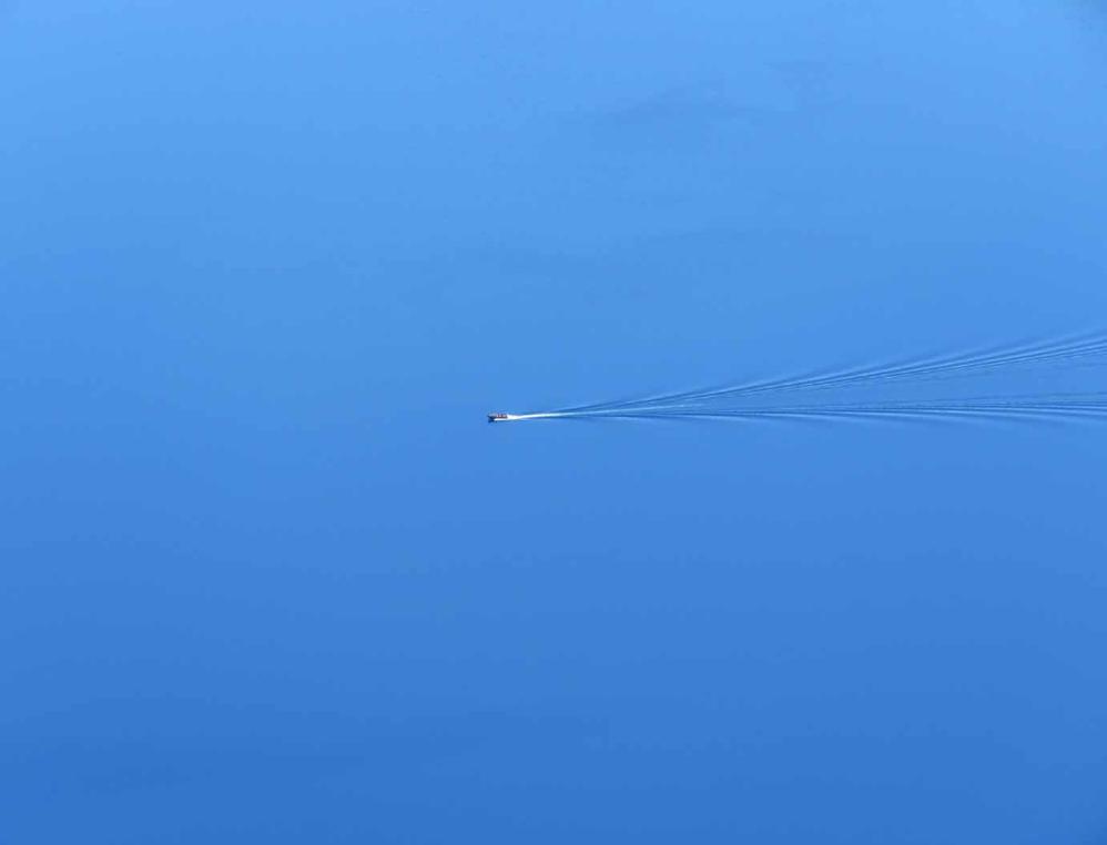
I used my compact super-zoom camera with 65X optical zoom to zoom in and saw a 2-person power boat
(One person in front seat and a second person in the back seat) cruising at high speed on the Crater Lake
with a long wake behind it.
(One person in front seat and a second person in the back seat) cruising at high speed on the Crater Lake
with a long wake behind it.
深藍色的湖面上隨著遊船激起漣漪波紋,好美的景色, 如仙境般的美!
I reduced the zoom somewhat to get a larger picture of the boat cruising in the large Crater Lake. It's
absolutely beautiful.
I reduced the zoom somewhat to get a larger picture of the boat cruising in the large Crater Lake. It's
absolutely beautiful.
I reduced the zoom entirely to show what the naked eye or an iPhone camera or a regular smartphone
camera will see this boat cruising on the large Crater Lake. The boat becomes so small that it is just a tiny
white spec barely visible on the lake in front of Wizard Island. It is a peaceful serenity of a natural, unspoiled
setting.
These three pictures together above are good demonstration of the huge size of Crater Lake relative to that
of the power boat.
As a size comparison, the top of the Wizard Island (巫師島) in Crater Lake is 755 feet above the water
surface of Crater Lake. This Wizard Island is known as a volcano within a large volcano (火山中的火山).
The Wizard Island has another smaller volcanic crater on the top about 500 feet (150 m) wide and 100 feet
(30 m) deep.
To reach the boat dock for boarding the boats on Crater Lake, visitors must be in good physical condition
capable of descending and ascending the Cleetwood Cove Trail. It is a one-mile strenuous trail that drops 700
feet (213 meters) to the boat dock on lake shore. The steep, dusty trail is challenging for some people at the
high altitude of Crater Lake with thin air. Please see (1) the comment of one of the visitors on the similar one-
mile trail to reach the Watchman Peak in the following and (2) the capped and squashed empty water bottles
at the end of this website.
Map: Click here for interactive Google Map showing location of Cleetwood Cove Trail to reach the boat dock
of Crater Lake


如夢似幻的湖泊,從這個角度便可以看到 Phantom Ship 鬼船的神祕身影,形狀像漂浮
在火山湖中的一艘船,在樹林光影之間讓鬼船又多了一些神秘感,神秘而攝人心魄。
Phantom Ship as viewed from Phantom Ship Overlook. It is a small island in Crater Lake. It is a natural rock
formation pillar which derives its name from its resemblance to a ghost ship, especially in foggy and low-light
conditions.
Map: Click here for interactive Google Map showing location of Phantom Ship Overlook
The small white patch on the far side of this picture is a patch of snow under the pine forest covering a small
beach at the lake shore.


望著這一片極深極藍彷彿有著魔力的湖水,在陽光下如寶石般閃閃發光, 雖然看起來像
是一艘小小的船,但是其實這座島有 16層樓的高樓一樣高呢。這座小島是由 400,000 年
前防侵蝕的岩漿堆積而成,是火山地形之間暴露在空氣之中最古老的一塊石頭。
Zoom in for a closer view of the Phantom Ship. Simply amazing.
是一艘小小的船,但是其實這座島有 16層樓的高樓一樣高呢。這座小島是由 400,000 年
前防侵蝕的岩漿堆積而成,是火山地形之間暴露在空氣之中最古老的一塊石頭。
Zoom in for a closer view of the Phantom Ship. Simply amazing.

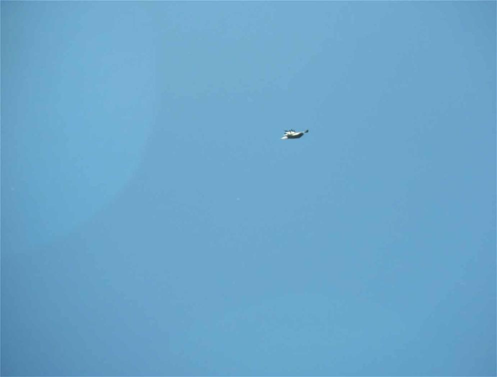
We saw a big bird flying high in the sky.

At this viewing angle, the top side of this big bird seems to be quite shinning under the sun. I am not sure if it is
an eagle or a hawk.
an eagle or a hawk.

Looking almost straight down from the top of a cliff, slightly lighter blue color at the shallower part of Crater
Lake.
Lake.

Looking straight down from the top of a cliff, much deeper blue color at the deeper part of Crater Lake.
The top part of this big bird seems to be shinning at this viewing angle. The white tail may be an indication of
a mature bald eagle.
a mature bald eagle.

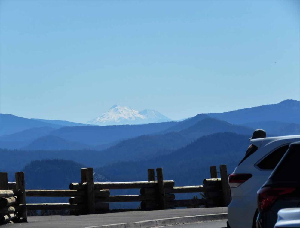
Zoom in on the majestic snow capped Stratovolcano, Mt Shasta, as viewed from the large parking lot (7600
feet above sea level) of Watchman Peak Trailhead along the Rim Drive of Crater Lake. The summit elevation
of Mt Shasta is 14,180 feet and it is 113 miles south in California. In addition to the main peak, the secondary
peak, Shastania, is also visible.
Here we are looking at a massive Stratovolcano (Mt Shasta) from Crater Lake which is the caldera of
another massive and collapsed Mount Mazama Stratovolcano about 113 miles apart. Both of them are on the
Ring of Fire around the Pacific Ocean.
Map: Click here for interactive Google Map showing location of Watchman Peak Trailhead
這樣深而純淨的極藍,彷彿有著魔力的湖水,周邊岩壁陡峭。有像西方巫師所戴的尖頂
帽而得名的巫師島, 大火山口中的小火山口, 近乎完美的錐形火山頂,非常誘人。
The air is crisp and clean, the sun warm, the sky and the lake a deep blue. The 33-mile Rim Drive around the
Crater Lake, with many overlooks, vista points and pull overs, affords one endless opportunity to stop and
enjoy the spectacular views of the Crater Lake National Park.
Awesome and pristine. The sight of the lake itself was absolutely spectacular and was an astounding site.
Nature is awesome! It is simply spectacular. The clearest way into the Universe is through a forest
wilderness.
wilderness.
火山地形特有的尖塔。
遠山的呼喚。
Mt. Thielsen viewed from Crater Lake. It is one of several volcanic mountain peaks in Oregon.
Mt. Thielsen viewed from Crater Lake. It is one of several volcanic mountain peaks in Oregon.

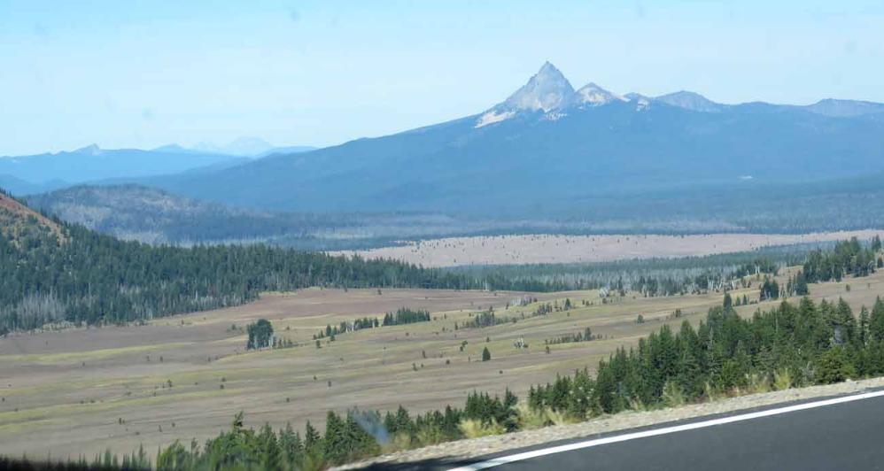
Another view of Mt. Thielsen viewed from Crater Lake.


The Trailhead for hiking trail up to Watchman Peak on the rim of Crater Lake.
The trail is just under one mile long, providing access for park visitors and rangers from the Watchman
overlook parking lot (7600 feet above sea level) to the Watchman Observation Station at the summit (8013
feet above sea level). The trail follows its historic route that begins at the base of Watchman Peak, follows
the original alignment of the old Rim Road for approximately 300 yards, then climbs a series of switchbacks
up the steep slope of the peak to the observation station at the top.
The Watchman Observation Station, located on the summit of Watchman Peak, serves as an
interpretive/educational center and as a fire lookout, providing commanding unparalleled views of Crater
Lake. The photos and the breathtaking views from Watchman Observation Station can be seen here.
The hiking trail is moderately steep with a 15 percent grade. But the comment from one of the visitors is
"The high elevation in this area however was murder for me, I live at 800' above sea level, so even though
this trail may be listed as moderate, but the elevation gain at such high altitude for me made this one
strenuous. "

More of the parking lot (7600 feet above sea level) of Watchman Peak Trailhead along the Rim Drive of
Crater Lake.
Crater Lake.

Another view of the Watchman Peak, the
beginning (lower) portion of the hiking
trail up to the peak and part of the
Trailhead Parking Lot.
beginning (lower) portion of the hiking
trail up to the peak and part of the
Trailhead Parking Lot.

湖水藍的晶瑩剔透, 如藍寶石一般, 堪稱人間仙境,寧靜之美。
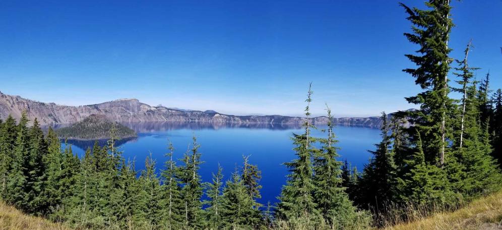
In view of the huge size of Crater Lake, I took several astonishing sweeping panoramic photos at several
different vista points along the Rim Drive to soak up the unobstructed scenic splendor of the deep blue Crater
Lake, a place of lush natural beauty and scenic inspiration.
In view of the huge size of Crater Lake, I took several astonishing sweeping panoramic photos at several
different vista points along the Rim Drive to soak up the unobstructed scenic splendor of the deep blue Crater
Lake, a place of lush natural beauty and scenic inspiration.


湖水澄清如明鏡!
Beautiful mirror reflection of the rim of Crater Lake.
Beautiful mirror reflection of the rim of Crater Lake.


Experience the sheer beauty and magic of nature, the stunning part of the world.
天空也湛藍如寶石。
Like music and art, love of nature is a common language that can transcend political or social boundaries.
Like music and art, love of nature is a common language that can transcend political or social boundaries.
Truly nature's work of art.
另外一面看到山巒層層疊起也很壯觀。
It is so blue!