| Click here for Home Page to see List of All My Trips and Three Methods to search my Travelogue website for web pages of interest to you |
| Waterpocket Fold and Burr Trail - Part 7 of 11 of 2010 Tour of fantastic Southwest USA |
In case if you see overlapped lines of text or some lines of text become obscured behind a picture on this web
page, please change the page magnification (zoom) factor to eliminate such problems by pressing these two
keys "Ctrl +" simultaneously or these two keys "Ctrl -" simultaneously.
Please press the F11 key on your keyboard to get full-screen view of photos and web page. Pressing F11 key
again will return to your normal screen with various tool bars.
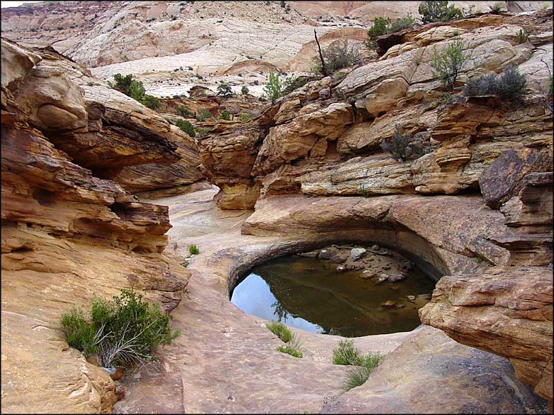
Then we saw this Peek-a-Boo Arch in the Waterpocket Fold.
The second level of switchback from the top. These tight switchbacks are not considered suitable for RVs or
vehicles towing trailers.
vehicles towing trailers.
Getting close to the second switchback. The switchback roads and hairpin turns perched precariously on the
edge of mountains. Wow! Scary, but fun.
edge of mountains. Wow! Scary, but fun.
赤壁丹崖,兩側絕壁對峙,如刀劈斧削,群峰競秀, 空谷幽長, 景
色壯麗。
The Long Canyon portion is 7 mile long with fantastic views of towering red cliff along Burr Trail.
These photos of Long Canyon were taken through the front wind shield of the car while we were driving on the
Burr Trail through the Long Canyon. The wind shield was dirty causing some spots on the photos.
壁立萬仞之險。
From Boulder along Scenic Byway 12, we drove east on Burr Trail to go to the southern part of Capital Reef
National Park on the morning of June 3, 2010. The 30-mile section of Burr Trail from Boulder to the border of
Capital Reef National Park is paved. But once inside the southern part of Capital Reef National Park, the 17-
mile section of Burr Trail inside the Capital Reef National Park is unpaved gravel road.
Burr Trail is named after John Atlantic Burr, who built the original cattle trail through this wild country in the late
1800's to expand grazing opportunities for Boulder cattlemen to move cattle back and forth between winter
and summer ranges and to market.
Map: Click here to see Google Map showing Boulder at junction of Burr Trail and Scenic Byway 12
The Waterpocket Fold is a giant wrinkle or buckle in the earth crust that extends almost 100 miles long through
Capital Reef National Park between Thousand Lake Mountain in the north end and Lake Powell in the south
end. This dramatic, colorful rock wall goes on for 100 miles in north-south direction, but is only a few miles wide
in east-west direction. In other words, layers of sedimentary rock here were warped and bent into a long spine
of rock, several miles wide.
Pressure deep within the Earth caused the overlying horizontal rock layers to be pushed upward and folded
over. Today this monoclinal structure appears as a giant step with one sloping side that ends in an abrupt sheer
cliff line. The east side of the Fold is tilted as much as 60% from the normal horizontal plane. The west side, or
escarpment face, is a near vertical cliff line with colored horizontal layers and is a formidable barrier to travel. If
you were northeast of the Waterpocket Fold, it looks like you could walk up a long slope to the edge on solid
ground, but at the end you would be faced with a sheer cliff with severe drop of thousands of feet to the earth
below.
Some people said that this "long spine of rock" in the Strike Valley looks like the back of a giant alligator with
ridges and spikes. This can be seen in the sample photos from the Strike Valley Overlook at the following
websites:
http://en.wikipedia.org/wiki/Waterpocket_Fold
The "Waterpockets" themselves are eroded "potholes" in the stone layers that fill with rainwater like a bowl,
and, until the water evaporates, make that moisture available to nearby plants and visiting wildlife in this
countryside mostly characterized by barren rock desert. The vast expanse of white Navajo Sandstone atop the
sloped side of the monocline is dotted with numerous natural tanks or potholes that collect rain water,
contributing the name "Waterpocket" Fold. These Waterpockets may hold water for months after a rainstorm.
Sample photos of such "Waterpockets" can be seen at the following websites:
http://www.sangres.com/cimages/np/capitolreef/pothole01big.jpg
http://www.terragalleria.com/photo/?id=care0748&keyword=waterpocket-fold
http://www.sangres.com/cimages/np/capitolreef/pothole02big.jpg
Navajo Sandstone white domes resemble the rounded roof of the Capitol building, hence the name "Capitol."
Many early travelers were former sailors who likened the vertical cliffs of Wingate Sandstone in the giant
Waterpocket Fold to a barrier common in nautical travel: a "Reef. " The 'reef' refers to the Waterpocket Fold
which is a huge, long stretch of rock. The ridge is called a reef because the steep cliffs block travel across
land, like a coral reef impedes ships. The early settlers named it 'reef' because it created such a barrier to
travel. These are key contributing factors to the name of Capital Reef National Park.
John Wesley Powell named this remarkable geologic feature the "Waterpocket Fold."


壯麗丹霞地貌,奇特景觀。
Spectacular Long Canyon with towering red cliffs along Burr Trail which is one of the most scenic backroads in
America. Burr Trail goes from mountain small town of Boulder in the Grand Staircase Escalante National
Monument into southern part of Capital Reef National Park in Utah, USA. This backroad is all about the views
and thrills. It offers an outstanding viewing platform for the geologic wonder and the most stunning wilderness
in the southwest.


After the 7-mile Long Canyon, Burr Trail took us through an area known as Circle Cliff Amphitheater with
different kinds of spectacular views as shown in these 9 photos.
different kinds of spectacular views as shown in these 9 photos.


老林在 國家公園留影。
After descending from the Circle Cliff Amphitheater, we came to the border leaving the Grand Staircase-
Escalante National Monument and entering the southern part of Capital Reef National Park. A picture of me
(Sing Lin) with my camera and my monopod - This photo by May Lee
Map: Click here to see Google Map showing Burr Trail at border of Capital Reef National Park
The Burr Trail descending from the Circle Cliff Amphitheater towards southern part of Capital Reef National
Park.
Park.
We began to see the panoramic view of the jagged, brilliantly-colored sheer cliffs of the west side of the
Waterpocket Fold in Capital Reef National Park.
Waterpocket Fold in Capital Reef National Park.


Then we saw a big gap in the Waterpocket Fold ahead. Here in Burr Canyon, the Navajo sandstone has
been completely eroded away, leaving a huge notch in the Waterpocket Fold
been completely eroded away, leaving a huge notch in the Waterpocket Fold

Then, the unpaved Burr Trail took us to the Burr Canyon switchbacks on the high rim of Waterpocket Fold for
the thrilling of driving down the hairpin switchbacks to descend 1,000 feet in only one- half mile to reach the
Strike Valley below. The unpaved gravel road winds like a snake to the desert floor below. The scenic view
to the east is superb. The peaks of the Henry Mountains can also be seen from this viewpoint. This series of
6 tight switchbacks cuts through the Waterpocket Fold are shown in the following series of photos.

This is near the first switchback on the left side of this picture.

赤壁丹崖絕壁如刀劈斧削。
Looking up on the big red rock at the First switchback.
Looking up on the big red rock at the First switchback.


The third level of switchback

峰迴路轉,蜿蜒迂迴穿行於山體絕壁。
The third level of Switchback.
The third level of Switchback.

Getting close to the third switchback.

Rock wall at the third switchback.

Fourth level of switchback.

Fifth level of switchback

Looking down from fourth level of switchback.

Sixth level of switchback.

Looking up from the bottom of the 6 switchbacks. You can't help but feel a sigh of relief when the bottom has
arrived and you can look to the top where you had just been.
Another set of good photos of this series of switchbacks from a different perspective can be seen at the
following websites:
http://www.flickr.com/photos/bobpalin/2569854442/in/set-72157605480227640/
Map: Click here to see Google Map showing location of this series of Switchbacks on Butt Trail

This is the view on Burr Trail coming out of the winding canyon at the bottom of the switchbacks and looking
to the other side of cliff of the Strike Valley.
to the other side of cliff of the Strike Valley.

We then turn north into Notom-Bullfrog Road which is also an unpaved gravel road. This road is parallel to
and on the east side of the Waterpocket Fold and go north for about 30 miles to reach the paved highway
24. So, while driving north, we are now seeing the sloping east side of the Waterpocket Fold (as a contrast
to the sheer cliff on the west side).
and on the east side of the Waterpocket Fold and go north for about 30 miles to reach the paved highway
24. So, while driving north, we are now seeing the sloping east side of the Waterpocket Fold (as a contrast
to the sheer cliff on the west side).

We saw 2 or 3 big bird (may be hawk or golden eagle) in flight while we were driving in the southern part of
Capital Reef National Park. But they were too far away for me to make a positive identification.
Capital Reef National Park. But they were too far away for me to make a positive identification.

We saw the backside of the Capital Dome. One of these white domes looks like the roof of Capital building
when viewed from the paved Scenic Drive on the other side in Capital Reef National Park.
when viewed from the paved Scenic Drive on the other side in Capital Reef National Park.

One of the big bird landed on a cliff ledge. It seemed that there might be a baby bird on the right side.

As we drove north on Notom-Bullfrog Road, the scenery gradually became more like the typical beautiful
scenery of northern part of Capital Reef National Park that we had seen and enjoyed in our previous trip in
2003.
scenery of northern part of Capital Reef National Park that we had seen and enjoyed in our previous trip in
2003.

After we arrived at the junction with the paved Highway 24, we drove north on Highway 24 to tour other
Points of interest that will be presented later.
In our previous trip in 2003, we used a regular car that confined us to those scenic vistas reachable by the
paved scenic drive in northern part of Capital Reef National Park. This time we had a 4X4 4-Wheel Drive
vehicle and a nice sunny day that gave us more freedom to explore the raw beauty of gorgeous, stunning,
wild desert country in the quiet, southern part of Capital Reef National Park without big crowds.
However, during the period of bad weather, if these unpaved roads become wet, soft and muddy, they may
become impassable not only for regular car, but also for 4-Wheel drive vehicles.
On the other hand, for seasoned backpackers in great physical shape, these two unpaved roads provide
access to several hiking trails to explore and to enjoy several special attractions, such as Strike Valley
Overlook, Upper Muley Twist Canyon, an unusual double arch, Lower Muley Twist Canyon, Halls Creek,
Hole-in-the-Rock, the Wolverine Petrified Forest, Surprise Canyon, the Gulch, Horse Canyon, Little Death
Hollow, Silver Falls Creek, Moody Canyon, Halls Creek Overlook, Brimhall Natural Bridge, Studhorse Peaks,
Saddle Arch, slot canyons in the Long Canyon on the north side of the Burr Trail, the Long Canyon
overlook, etc.
Our 10-Day 2010 Tour Route of Southwest USA is a large loop starting and ending in Las Vegas in Nevada,
USA. The sequence of fantastic Point-Of-Interest (POIs) on this large loop is:
Las Vegas in Nevada --------> Kolob Canyon in Zion National Park in Utah ---------> Cedar Break National
Monument in Utah --------> Red Canyon State Park in Utah --------> Bryce Canyon National Park in Utah
--------> Scenic Byway 12 through beautiful Grand Staircase-Escalante Monument in Utah --------> Scenic
Burr Trail and southern Part of Capital Reef National Park in Utah --------> Goblin Valley State Park in Utah
--------> Dead Horse Point State Park in Utah --------> Canyonland National Park in Utah ---------> Arches
National Park in Utah --------> Goosenecks State Park in Utah --------> Monument Valley in Arizona
-------->
Antelope Canyons in Arizona --------> Glen Canyon Dam and Bridge over Colorado River in Arizona
-------->
Horseshoe Bend of Colorado River in Arizona ---------> Navajo Bridge over Colorado River in Arizona
--------->
Scenic Highway 89-ALT from east to west along beautiful Vermilion Cliffs National Monument in Arizona
--------> Grand Canyon - North Rim in Arizona --------> Valley of Fire State Park in Nevada --------->
Hemenway Park in Boulder City in Nevada ---------> Las Vegas in Nevada.
The road starts dropping down into narrow canyons by clinging to narrow ledges that switchback their way
down to the narrow valley floor of the Long Canyon. From here the scenery along the colorful gorge gets
really good. Sheer red rock walls climb several hundred feet up towards the crisp blue skies creating
stunning color contrast while the road snakes its way between the empty creek bed (unless it is raining) and
the steep rock walls.
Map: Click here to see Google Map showing the switchback on Burr Trail to go down into the Long Canyon
This narrow canyon is enclosed by sheer walls of Wingate sandstone which tower hundreds of feet above the
road. The lighter, golden sandstone crowning the red cliff is known as the Diadem. During the sunset golden
hour, the reflections of the low-angle golden sunlight from red sandstones can turn into amazing array of rich,
intensive, brilliant, gorgeous, golden hues and glow similar to what we saw in Monument Valley as reported in
Part 3 of this tour.
怪石嶙峋之秀。
This photo shows a powerful wind erosion phenomenon resulting in cavernous rock known as Swiss cheese
along Burr Trail.
This photo shows a powerful wind erosion phenomenon resulting in cavernous rock known as Swiss cheese
along Burr Trail.
Surrounding this area are the Circle Cliffs, named by John Wesley Powell. The great oval arena within the
uplifted circle of cliffs eroded from the center, exposing the red sandstone cliffs which enclose it.
uplifted circle of cliffs eroded from the center, exposing the red sandstone cliffs which enclose it.
Part 8 of 11 entitled "Goblin Valley and San Rafael Swell - Part 8 of 11 of 2010 Tour of fantastic Southwest
USA" is on my web page at:
http://www.shltrip.com/Goblin_Valley.html
USA" is on my web page at:
http://www.shltrip.com/Goblin_Valley.html

| 讀萬卷書 行萬里路 |

How I use information age technologies to enhance my enjoyment greatly of sightseeing large driving tour
loop of thousands of miles and of one to two weeks in duration covering many Points of Interest is described
on my web page at:
http://www.shltrip.com/Sightseeing_in_Information_Age.html
loop of thousands of miles and of one to two weeks in duration covering many Points of Interest is described
on my web page at:
http://www.shltrip.com/Sightseeing_in_Information_Age.html